This site captures the adventure of Wallace and Bob as they section hiked the Appalacian Trail (AT) through Shenadoha National Park. This 105mile southbound trek through the Blue Ridge Mountains began May 25, 2007. The hike took 8 days to complete. Here is the story.
BACKGROUND
In the summer of 2006, Greta, Traz, and I were planning a trip to Shenandoah National Park in Virginia. In the past, we had always camped at Big Meadows located right in the middle of the park. This year, we decided to try something different. Loft Mountain campground located about 30 miles south became the destination. As part of the “getting psyched” for the vacation routine, I googled Loft Mountain and found the web journal of Snuffy. Click here to see his journal. Snuffy section hikes the AT and posts his journal entries. Reading this journal, was the first thing that started to stir my interest in hiking the AT even though I did not realize it at the time.That July when were “car camping” at Loft Mountain, we met a retired ER physician and his wise a retired substitute school teacher. There "trailnames" were Camel and Little Billy Goat Gruffs. They were hiking 900+ miles. That is when I decided that I wanted to do a section hike. I decided to try to do the length of Shenandoah, about 105 miles the next summer. It was really hot in July when we were at Loft, so I thought late May would be a great time. The park facilities would all be open, the foliage would be out to provide shade, the weather would be on the cooler side, the rhododendrons and mountain laurel would be blooming.When I got home, I started to tell people my new ambition. I figured that if told enough people, it would be harder to back out. The plan worked.
PLANNING
I started asking some of my friends that I thought might be interested in joing me on the hike. It is big commitment to do this not only from the stand point of the hike itself, or the stand point of using up a week of precious vacation, but from the stand point of spending that much time with me. Much to my surprise, two friends showed interest. In the fall of 2006, the three of us went on a day trip to the Delaware Water Gap and hiked the AT on the NJ side up to Sunfish Pond. (This is where I spent my first night as an evacuee from Three Mile Island with my college roommates back in 1979.) The hike was about 9 miles and we were carrying only daypacks containing snacks and water. After this trial run, only Bob was interested in pursuing the hike. Bob started to call himself Downhill Dawg as his trailname. Trailnames are a hiking tradition that people either give themselves or are named by others. Dawg posted a question on a web site dedicated to AT hiking about how the trail conditions at the water gap compared to those in Virginia. This was my first exposure to Whiteblaze.net. During the next 6 months, I read almost all the posts on this web site. I became obsessed with learning about the equipment that was available. Two main concepts emerged. 1. I wanted to be “Ultralight”. This meant keeping my pack weight as low as possible. 2. I wanted to camp using hammocks instead of tents or staying in the AT shelters.
I made my Christmas wish list and received a Gossamer Gear G4 pack that weighed in at about 1 pound. I also got a Hennesey Hammock Ultralight hammock that came in around 2 pounds. Add in my 4-ounce stove and 8 ounce jacket and I was well on my way to have a pack that weighed less than 20 pounds not including water.
Later that year, I picked Homer as my trail name. It comes from the great Philosopher, Homer Simpson. The number of similarities between his life and mine are uncanny.
Here is the map of Shenandoah National Park (SNP). You can click on it to zoom in. This image will help you follow the progress.

On Friday, May 25 at 4:00 am, Dawg picked up Homer in NJ and then headed down I-95. We left at 4:00 to make it through the Washington DC beltway traffic before the morning rush. We were too late. I-495 was already backed up. This was just a brief delay however. Before we knew it, we were in Front Royal, VA. We found a little breakfast diner for a quick meal before hitting the trail. After a quick bite, we entered the park and drove 5 south on Skyline Drive to the Dickeys Ridge Visitor Center.

That first day, we hiked down to the AT and then some. We had our first experince at getting water from a spring. The magnitude of the task before us became clear. The climbing and elevation gains with a fully loaded pack proved to be a challange. Fine tuning of our pack loadings were required. The importance of watching every step to avoid twisted ankles became painfully obvious. Here is Dawg after some elevation gains.

We camped that night just off the AT, a little shy of our daily goal but far enough along to recover. Here are some pictures of our hammocks set up the first night.


We had our first dinner on the trial. Dehydrated Mountain House dinners spiced up with a little cayenne pepper. These are surprisingly good. You just add 16 ounces of boiling water to the mylar pouch, let sit 5 to 10 minutes and eat right out of the pouch. We then hung our food in stuff sacks from a tree 10 feet abouve the ground to keep the animals away. Although we were a little rough with our techniques since it was our first night, our final camp looked like that of professionals.
The next morning as we broke camp and had breakfast. I was sitting on the ground eating and decided to stand up. When I did, I startled a bear that took off running. It was probably about 40 to 50 yards away. I don't think it saw me and was a little spooked when I stood up. The bears in SNP are black bears. They don't eat people but would love to get there paws on your picnic baskets.
That day, after about 9 miles, Dawg's knee started to act up and he yellowed blazed about 4 miles to the Elkwallow wayside and waited for me. I did not realize it at the time, but this was the beginnig of the evolution in trail names for Bob from Dawg to Thumbs. I caught up a little while late at the wayside. There was a bobcat in the parking lot. Here is the picture.

For those that don't see it, the bobcat is the tractor like vechicle parked in the middle. That is an example of the tremendous wit and humor I treated thumbs to all week. He was very lucky. (that is sarcasm).
We ate at the wayside and then camped less than a mile into the woods just off the AT south of the wayside. Here is our camp.


The next day we did some good hiking. We started to get into the higher mountains. We hiked down to Thorton Gap where Route 211 crosses through the park. Here are some pictures from the higher elevations.


When we got to Thorton Gap, we decided to take a long luch break. You see, the thing about places called gap is that they are low spots in the mountains. Leaving a gap always means hiking up hill. A gap that is low enough to have a road running through (Route 211) means that the uphill is even a steeper, longer climb. Hence, the long break was easy.
On this one, you can see skyline drive. Seeing the road alway gave you a sense of where you came from and where you are going since the road and the AT somewhat parallel each other.

 If you look closely at the next shot, you will see a pool of water in the rocks. You can't tell just how big it is but several people could sit in there. It looked like a nice resort hot tub. However, it was filled from last night's thunder storms and was very chilly despite the hot temps during the day.
 There were alot of great views from the ridge this day.
 This me at a trail intersection standing next to a sign that marks the highest point on the AT in the park.
 There is a tremendous amount of wildlife in the park and they are not affraid of people. This is a picture of a deer. I had seen 5 bears in 3 sitings and Thumbs had another siting with a mom and her cubs. We were unable to get any pictures of the bears.
 As I went by Skyland, I passed the horses that are boarded there.
I got to Big Meadows just before some rain. I had heard thunder in the background and rushed for the last 3 miles. There are trail markers in the park that tell how far you have to go. I kept counting down the distance to Big Meadows. Once I got there, a marker said it was another 1.2 miles to the lodge where we were staying that night. That was truely cruel. I was very beat and literly limped into the lodge completing my longest hiking day yet. Here is the lodge.
 There is a great porch overlooking the valley.

After a very nice dinner in the lodge, Thumbs phoned home and found that he had a family emergency that he had to attend to. He left early the next morning leaving me to finish my hike by myself. (Or so I thought).
I left big meadows freshly showered and with clean socks. The hike that day turned out to be one of the least demanding of the trip. I stopped at the Lewis Mountain Camp store that day to pick up something different for lunch. I met Joel and Jen, a couple from Virginia Beach that were doing the same hike. Thumbs had talked to them the day before at Big Meadows. I also met a women with the trail name Booger and her dog Buddy. I did not ask her the origin of her trail name. The four of left Lewis Mountain together and would pass each other several times during the day. I felt like part of the trail communitiy, knowing people and being greeted along the way. It was my favorite day of the hike. Here are some pictures of that day.
 The trail went right by this working cemetary. It was very quiet and peaceful here.
 There were long sections of the trail that just went through a green tunnel. Quiet solitude. It was here that I learned to just hike, one step after another and not think about getting somewhere. The jouney is the destination.
 That night as I approached Swift Run gap, I entered a part of the park that was damaged by an ice storm during the winter. All, and I mean all, the horizontal branches on the trees were ripped off and on the ground. This made it impossible to go off trail and find a place to camp even with the hammock. Finally, I saw what looked like a small side trail that was cleared. I went up the trail about 100 yards to find another, smaller, non-working cemetary. Since it was getting late and I had about 17 miles in for the day, I decided to split the 100 yards and set up camp right outside the cemetary. My first night in the woods alone and I'm camping at a cemetary. One more thing to be grartful for in this adventure. :)
I called thumbs this evening as I was able to get a cell signal by the gap. His family emergency was under control and he was returning. We met at the park entrance station at Swift Run Gap that morning. (Where Router 33 crosses the drive). Once again, leaving a "gap" meant a high climb to a mountain called Hightop. Here are some pictures from the top.
 This next shot is very interesting. The peak at the very back is Loft Mountain about 15 miles further away and our destination for the evening. There is a campground and campstore there which means we can have a fire and buy hot dogs. True luxury on the AT. But looking at the picture carefully you can see that Loft is the fourth mountaion (fifth if you include the one we are standing on). That is our path for the day. It was cool to see exactly where we would be going the rest of the day. You normally don't get such a perspective.
 Two more pictures from the top.

 The next 4 pictures are the last I took before my camera experienced a failure. We were one moutain and 4 miles out from Loft Mountain Campground.


 From here, Thumbs retrieved his car and was able to purchase the hot dogs, rolls, chips, relish, and mustard just before the camp store closed. I went the last four miles. I passed Joel and Jen down at Ivy Creek. This was the last time I saw them. I fnialy made it into Loft Mountain totaly exhausted. I was limping. We each had 4 hot dogs and settled down for the evening. In the morning, we had a bear come through our camp. All our food was stored away so he just left but I was able to see him from the comfort of my hammock.
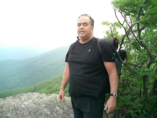
The next day, we left Loft mountain on the late side. We had breakfast at the wayside, had a shower, and I ran my socks and a few clothes through a wash. That evening, I set up camp after a brief shower at Wild Cat Ridge. Thumbs spent the night in Waynesboro. With the help of a couple of voice mail messages from my rapidly dying cell phone, we connected in the morning. Thumbs brought me some Mexican food for breakfast. Here is a picture in the parking lot where we met. I also dumped some of my pack belonging to lighten the load. This would be my last day on the trail before finishing at Rockfish Gap. Later that day, Thumbs met me for lunch at Beagle gap. He brought salami and cheese sandwhiches. While enjoying lunch, we met two through hikers heading north. M&M and Laredo. Click here to see M&M's trail journal of when we met and look at the next day's also where she mentions Greta and Traz. Here is me at Beagles gap.
After Beagle's gap I had only 6 miles left to finish the hike. The AT left SNP at parts during this section and I was amazed at the difference in the quality of the trail. I learned how well maintained it was in the park.
Several hours later I exited the AT at Rockfish Gap. Thumbs was there to take my picture when he realized that he had video capability. Here is the video of me coming off. I initially went back up thinking Thumbs needed time to figure out the video on his camera. Then the thought went through my head that as I crossed the road after this long hike, I would be hit by a passing vechicle.
Well, that is the story. Please leave a comment if you were here. Watch for updates in the years to come as new sections are done. Maybe next year I will hike the 100 mile wilderness in Maine. See you then.